Hike Mount Willey and Field

When:
Saturday, Dec 07, 2019 8:15a -
5:15p
Saturday, Dec 07, 2019 8:15a -
5:15p
Where:
Wellington Revere Beach Pkwy
Revere Beach Pkwy
Medford, MA 02155
Admission:
Unknown
Categories:
< 21, Date Idea, Meetup, Social Good, Sports & Active Life
Event website:
https://p.ridj-it.com/app/trips-search?id=41953
Before you properly sign up on the Ridj-it site, please answer the two following screening questions:
1) What previous winter or cold weather hiking experience do you have?
(Note: If you only have experience hiking abroad, when you answer this give names of specific mountains so I can compare them to this hike. The White Mountains are deceptively difficult given their elevation and some peaks can match the high peaks of the Rockies for elevation gain)
2) Will you bring everything on the below gear list?
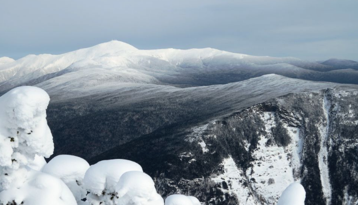
Mount Willey is the 29th tallest of the 48 4000-footers, and forms one side of Crawford Notch. From its peak besides the Notch you can see the whole of the Southern Presidentials, plus Mount Washington on a good day. Mount Field is slightly taller, at 4340 feet and 23rd highest, but has limited views. We will be climbing it this weekend to hopefully get a glimpse of Willey's views. Be warned though, this will be a true winter hike. We will be covering roughly 7.7 miles and 3300 feet of elevation gain.
A link to the trail map can be found here: https://www.alltrails.com/explore/map/map-9ca7f29e-2366-4b8a-b804-739a30e15a2f
Trail conditions can be found here: https://www.newenglandtrailconditions.com/peaks/nhmtwilley.php
Because we are going to be hiking in the winter, you must bring plenty of warm and waterproof layers, plus winter hiking gear. Here is the gear list:
Waterproof, winter-hiking boots
Microspikes
Gaiters
Water-resistant or waterproof pants, such as rain pants.
Non-cotton base layer (preferable wool or synthetic).
Non-cotton, breathable mid-layer
Water-resistant or waterproof hard/soft shell jacket
Hat
Gloves
Headlamp
2-3 liters of water that won't freeze. (Insulated water bottle or other method)
Snacks and lunch. You will be burning a lot of energy!
Snowshoes (I will confirm this and depends on the trail conditions)
A map of the hike. This could be an electronic Alltrails or GaiaGPS copy or a printed copy of the map.
-

SponsoredAffordable Spanish Classes in Boston (in-person and online courses) | BASE
Monday, Jul 07, 2025 goes until 07/18
Boston Area Spanish Exchange (BASE)
-

SponsoredDay Trip from Boston: Kayak Castle Neck River at Crane Estate
Saturday, Jul 05, 2025 11:30a
Crane Beach
-

SponsoredExplore The New England Botanic Garden at Tower Hill: Day Trip from Boston
Sunday, Jul 06, 2025 11:00a
New England Botanic Gardens at Tower Hill