Hike North Kearsarge - Moderate
When:
Saturday, Mar 31, 2018 9:00a -
3:00p
Saturday, Mar 31, 2018 9:00a -
3:00p
Where:
Wellington Station
Wellington Station Busway
Medford, MA 02155
Admission:
Unknown
Categories:
Date Idea, Meetup, Social Good, Sports & Active Life, Tech, University
Event website:
http://p.ridj-it.com/app/trips-search?id=8854
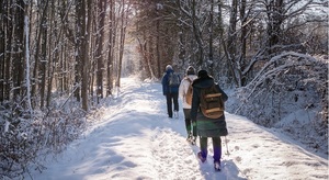
Mount Kearsarge North is a mountain on the 52 with a View List and is located in the Mount Washington Valley area. Thus, a steady, moderate climb on the Mt. Kearsarge North Trail leads to one of the finest views in the White Mountains. The open ledgy summit has an abandoned fire tower, which we can climb to see jaw-dropping 360 degree views of the Presidential Range, Carter Notch, Evans Notch, the Baldfaces, Mt. Carrigan, the Bonds and even Mt. Moosilauke.
Difficulty: Moderate due to the steep climb
Total Elevation: 3,268 ft.
Elevation Gain: 2,600 ft.
Total Mileage: 6.2 miles
Total Time: Approx. 4.5 hours depending on pace and amount of breaks.
In terms of height and difficulty, this mountain is on a similar scale to Mt. Cardigan (for those of you who hiked with me this past summer). Directions: The trailhead is located on Hurricane Mountain Rd. in Intervale. Take I-95 N to NH-16 N in Rochester. Follow NH-16 N to Hurricane Mountain Rd. in Bartlett. Turn right onto Mountain Valley Blvd. At the traffic circle, take the 3rd exit onto North-South Rd. Turn right onto Kearsarge Rd. Turn left to stay on Kearsarge Rd. Turn right onto Hurricane Mountain Rd. The trailhead will be on your left about a half mile from Kearsarge Road. Hike Details:
What to Bring:
Required. No Exceptions. No Cotton, Denim or Rayon Clothing Either:
Winter hiking boots
Heavyweight wool socks plus an extra pair or two
Two one-liter bottles, which should be filled with warm or boiling water. Water bladders will freeze, even with insulation. Please DO NOT bring a water bladder; otherwise, you will be turned away and not allowed to participate in the hike. Your water bottles should be stored upside down and insulated (you can use a wool sock).
Wool or synthetic base layer
Mid-layer, which can be a shirt, fleece and softshell pant
Hat, Parka and two pairs of gloves, ideally a liner glove and an overmitten
Headlamp (you can get by with a flashlight in a pinch). Please DO NOT use your cell phone as a flashlight.
Food!
Microspikes
Knee-high gaiters
• What to bring
Snowshoes***. Please bring snowshoes with you. At the trailhead, we'll evaluate the snow/trail conditions to confirm whether we'll actually take the snowshoes up the mountain. Snowshoes will also be available for rent on the way up to the mountain.
Optional, but Strongly Recommended:
Hiking or ski poles
Rain gear (top and bottom). These may or may not be required, depending on the weather forecast.
Face mask or balaclava
Sunglasses
Hand and foot warmers
• Important to know
Liability Release: You acknowledge and agree to the following: this activity involves inherent risks and assume all risk; you are responsible for having the necessary knowledge, skills, abilities, clothing, and equipment to safely participate in this activity; the organizer(s) of this activity are volunteers; and you release, hold harmless, and indemnify the organizer(s) and all members of this group from any and all claims for property damage, injury, illness, disability, and/or death.
-

SponsoredWBUR Earth Week Events
Tuesday, Apr 23, 2024 goes until 04/26
WBUR CitySpace at The Lavine Broadcast Center
-

SponsoredAffordable Spanish Classes in Boston (in-person and online courses) | BASE
Monday, May 06, 2024 goes until 05/25
Boston Area Spanish Exchange (BASE)